Friends of the Edisto (FRED)
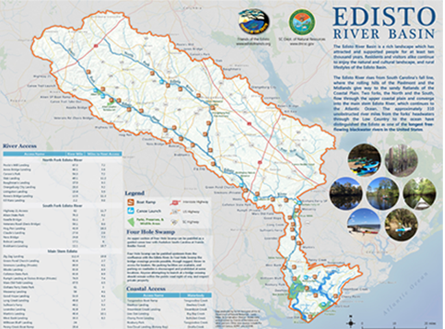
Edisto River Access
North Fork Edisto River
South Fork Edisto River
Edisto River
Coastal Access
ACCESS NAME
River Mile
Miles to Next
-81.1853, 33.6515 - From intersection of US 178 and SC Hwy 3, take SC
Hwy South and go .6 mi. across bridge on left. Limited parking.
-81.1355, 33.6069 – From US 178 and SC 394,go west on SC 394 (Salley Rd) for
1.4 mi. Landing on south side of river. Limited parking.
-81.1052, 33.5910 – On US 321, 1.7 mi. south of North, SC and 2.8 mi north of
Livingston, SC. Park is on south side of river, east of US 321.
81.0385, 33.5768 – From North, take US 178 east for 2.4 mi. Turn right on Slab
Landing Rd and go 3.8 mi. The landing is on south side of river.
-80.9472, 33.5255 – From Orangeburg, landing is on Shillings Bridge Rd on the
north side of river via either US 178 or SC 4. Limited Parking.
-80.87395, 33.48001 – South of US 301 from the Edisto Memorial Gardens. Can
be accessed from Andrew Dibble St via US 301 or Glover St.
-80.86977, 33.40166 – From US 301/601 west of Orangeburg, take Cannon
Bridge Rd south for 5.2 mi. then turn left on Livingston Landing Rd. Follow this
road to the landing. Limited Parking.
-80.8873, 33.35548 – From US 301/601 west of Orangeburg, take Cannon Bridge
Rd south for 8.9 mi. Turn left on River Dr. The landing will be on the left before
the bridge (west side of river). Limited Parking.
Kill Kare Landing 2.2
-80.88113, 33.28027 – From US 21 in Branchville, go west on Edward Rd for .6
mi. Turn right on Hudson Rd and go 3.3 mi. Turn left on Kilkare Ln. Road ends
at the landing.
ACCESS NAME
River Mile
Miles to Next
-81.56175, 33.63625 – New Holland Rd bridge. From I-20, take exit 33 on to
SC 39. In 4.4 miles, turn right on New Holland Rd. The landing is 6.5 miles.
From Aiken, take Cooks Bridge Rd east for 9 miles, then merge with New
Holland Rd just before bridge. Landing on east side of river.
-81.48355, 33.55564 – On east side of river at State Park Rd bridge. From US 78 east
of Aiken, turn left Old Tory Trl and continue 8 miles to park. Turn left on State Park
Rd. Aiken SP also has a 1.7 mile canoe trail with two canoe launches in the park.
-81.41019, 33.52013 – From SC 4 (Surrey Race Rd), turn south on Windsor
Rd/Spring Branch Rd. Cross bridge, landing on left. Limited parking
-81.39108, 33.50272 – From SC 4 (Surrey Race Rd), turn south on Veterans
Rd. Landing on right before bridge. Limited Parking.
-81.31341, 33.47836 - At the crossing of SC 39 (Springfield Rd). Ramp is on
south side of river. Limited Parking.
-81.26575, 33.45523 – Just north of the river on SC 3, turn onto Pig Pen
Landing Rd. Landing is at end of road, about 1 mile.
-81.11383, 33.38172 – From US 321 a mile south of the river crossing, turn
east on Charleston Augusta Rd. After 1 mile, turn left on Claude’s Landing
Rd. Landing at end of road.
-81.08254, 33.37555 – From US 321 a mile south of the river crossing, turn
east on Charleston Augusta Rd. After 2.7 miles, turn left on SC 70 (Country
Club Rd). Access north side of river on right. Limited Parking.
-81.02036, 33.33707 – Landing is at US 301/601 crossing on the south side of
river and west side of highway.
-80.96528, 33.31389 - From US 301 north of Bamberg, turn east onto Charleston
Augusta Rd for 3.4 miles. Turn left onto Faust St. and then left on Cannon Bridge
Rd. Access before bridge on left.
ACCESS NAME
River Mile
Miles to Next
-80.84443, 33.2169 – From US 78 just west of the river crossing, take
Farrell’s Rd south. Make a hard left at next intersection, and go 0.5 miles.
Take a right at Zig Zag Landing Rd. Landing at end of road. Landing is on
oxbow lake off of the main channel. See map for route.
-80.68968, 33.12587 - From I-95, drive Northwest on SC 61 for 3.7 miles and
turn right onto Salcro Lane. Landing is at the end of the road, on an oxbow
lake off of the main channel. See map for route.
-80.671372, 33.104028 - 1.5 miles north of I-95 on SC 61, turn right at the
sign for this landing. Use pay box for fee. Respect private property.
-80.61307, 33.06477 - From SC 61 and US 15, drive northeast on US 15 for 1
mile and turn left just after crossing the bridge over the Edisto River.
-80.6133, 33.06435 – Across the river from Week’s Landing
-80.52549, 33.06088 – From SC 61 and US 15, go east on SC 61 for 5.8 miles
and turn left on to Sidneys Rd. Continue for 0.8 miles, then veer left on dirt
road and continue to landing. Limited Parking. Do not block any driveways or
roadways. Respect private property.
-80.44962, 33.05479 - From SC 61 at Givhans Ferry, drive northwest for 4.8
miles and turn right Mars Oldfield Rd. Continue to landing.
-80.39027, 33.0305 - From Ridgeville, take SC 27 south for 6 miles and turn
right onto SC 61. Go three miles, then take right on Givhans Ferry Rd.
-80.40527, 33.00016 - From SC 61 and US 17A, drive northeast on SC 61 for
8 miles and turn left onto Old Beech Hill Rd. After 1.9 miles, turn right onto
Boat Landing Rd. The landing is at end of the road.
-80.4178, 32.9658 - From McDanieltown Rd and US 17A, take McDanieltown
Rd north for 2.8 miles. Turn right onto Good Hope Landing Rd. The landing
is at the end of the road.
-80.4017, 32.9342 - From McDanieltown Rd and US 17A, take McDanieltown
Rd north for 0.4 miles, and turn right onto Long Creek Landing Rd. The landing
is at the end of the road.
-80.40675, 32.91213 - From Camp Buddy Rd and US 17A, drive south on
Camp Buddy Rd for 1.1 miles and veer left onto Stump Knocker Rd. The
landing is at the end of the road.
-80.4033, 32.87078 - From US 17A and Sullivan’s Ferry Rd (dirt road), 2.5
miles east of river crossing. Veer southeast on Sullivan’s Ferry Rd for 1 mile
and turn right onto Parkers Ferry Rd/Lowndes Landing Rd. Continue for 3.9
miles until the river and landing appear on the left.
-80.39454, 32.84363 – From US 17A river crossing, turn south on Sullivan’s
Landing Rd about 0.5 miles west of bridge. Continue for 5.8 miles (Sullivan’s
Landing Rd will turn into Parker Ferry Rd). Take right on Martin Landing Rd.
Accessible from US 17 by turning north on Parker Ferry Rd.
-80.45163, 32.73626 – From US 17, turn south on Hope Plantation Ln. After
2.5 miles, make left on West Bank Landing Ln.
24
-80.41621, 32.67895 – From US 17 about 3 mile east of the river crossing,
turn south on Parkers Ferry Rd. Go 5 miles and then veer onto Willtown Rd.
Continue to river and boat ramp. Limited Parking.
28.4
-80.41043, 32.73482 – From US 17, head south on Parkers Ferry Rd for one mile,
then take a right on Penny Creek Rd and continue to landing. Limited parking.
ACCESS NAME
River Mile
Miles to Next
Toogoodoo Boat Ramp
- Ramp

-80.29628, 32.68870 – From US 17, head south on SC 174 for 4.9 miles, then
turn left on to Toogoodoo Rd. After 3.5 miles, take a right onto Parishville
Rd. When the road begins to turn sharply to the right, veer left to landing.
Limited Parking. Toogoodoo Creek.
Dawhoo Landing
- Ramp

-80.34100, 32.63573 – The road to the landing is 0.5 miles south of Dawhoo
Creek off of SC 174 (Edisto Island National Scenic Byway). Dawhoo Creek.
-80.29313, 32.60221 – From SC 174 (Edisto Island National Scenic Byway),
turn north on Steamboat Landing Rd and continue to landing. Steamboat Creek
Live Oak Landing
- Ramp

- Fee Area

-80.32321, 32.50237 – From SC 174 (Edisto Island National Scenic Byway),
turn west on to Palmetto Rd. In 1.3 miles, take a left on to Oyster Row Ln
and continue to landing. Landing is in Edisto Beach State Park. Big Bay Creek.
Cherry Point Landing
- Ramp

-80.18274, 32.59801 – From SC 700 on the southern end of Wadmalaw
Island, head east on Cherry Point Rd. In 1 mile, take a right to boat landing.
Limited parking. Bohicket Creek
Roxbury Park
- Canoe/ Kayak Launch

-80.34591, 32.68594 – Only open on the weekends. Call Town of Meggett to
check status. From US 17, go south on SC 174 for 5.5 miles. Just after crossing
creek, entrance to park is on the left. Toogoodoo Creek.
Sea Cloud Landing (Botany Bay)
- Canoe/ Kayak Launch

-80.25005, 32.56083 – From SC 174 north of Edisto Beach, turn east on
Botany Bay Rd. Take next left on Rabbit Rd. At 1.5 miles, take sharp left and
continue to landing. No trailers, car-top boats only. See SCDNR website for
hours and closures due to hunting. Ocella Creek
Edisto Riverkeeper

Follow FRED
on Social Media
on Social Media


