Recreational Boating
The Edisto River Basin supports a variety of recreational boating opportunities. These range from paddling the narrow, winding, tree-clogged upper reaches to motoring the Intracoastal Waterway and sea kayaking the salt marshes. In between, one can find canoes, kayaks, small and large fishing boats, ski boats, and jet skis. Over 250 miles of the Edisto River system were classified as superior resources of statewide or greater significance for flatwater boating and backcountry boating in the 1988 South Carolina Rivers Assessment.
Edisto Access Sites -- See below a list of websites providing maps and information for boating the Edisto River system. Further below is a list of boat landings and other access sites by county and river sections, and the list provides river mileage (RM) to help with trip planning.
Paddle SC provides an online map and guide to accessing rivers and waterways of South Carolina. Featured sections of the Edisto are:
Edisto River Canoe and Kayak Trail (ERCK trail) is a 56-mile trail on the Edisto River's main stem. Find the ERCK trail map here. Found along the trail are two of South Carolina's state parks: Colleton and Givhan's Ferry. Both offer camping and picnicking.
Boating Guide to the Edisto River Basin - published in October 2017, this guide is available from the SC Department of Natural Resources for $10 -- See the DNR website for instructions on how to order copies.
Aiken State Park - Natural Area has a canoe trail on the South Fork of the Edisto River near Aiken.
Francis Beidler Forest is a National Audubon Society Sanctuary in Four Hole Swamp with a braided-riverine bottomland-hardwood swamp reported containing the largest old-growth stand tupelo-cypress in the United States. The 15,000-acre sanctuary supports many birds, mammals, reptiles, amphibians, and many rare plants. Call them at (843) 462-2150 or go to their web site.
ACE Basin is a region of exceptional natural diversity within the coastal areas of the Ashepoo, Combahee, and Edisto Rivers of South Carolina. The Nature Conservancy has called the ACE Basin one of the "last great places.” More info on the ACE Basin is provided on our Introduction to the Edisto page.
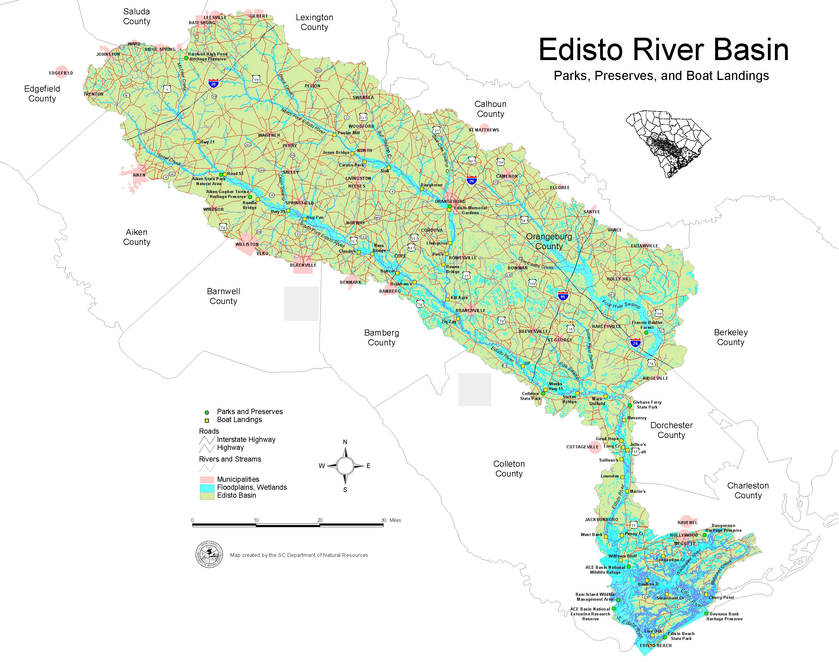
Edisto Access Sites
Below is a list of places (landings, parks, and preserves) that provide access to the Edisto River Basin's waters. Two lists are provided to describe access sites' location to waters of the Edisto River system, which are used by the public. Many sites (not all) on the list are public boat landings free for public use. Several sites are listed here: parks or private-access areas where user/entrance fees may be required.
The first list presents access sites by their county and river locations.
The second list presents the access sites by river systems, listing the sites from upstream to downstream locations with river mileage (RM) figures provided for most areas; also described are the upstream and downstream river endings.
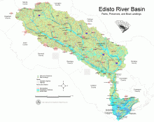
Click here to see the Map of Edisto River Access Sites - (Map is extensive, be patient)
Edisto Access Sites by County and River ~ ~ ~ ~ ~ ~ ~ ~ ~ ~ ~ ~
Aiken County - South Fork Edisto River
- Highway 21 Landing (at Road 21 bridge, east of Aiken)
- Aiken State Park / Natural Area (at Road 53 bridge)
- Road 53 Landing (bridge at Aiken State Park)
- Keadle Bridge Landing (at Windsor Road bridge)
- Aiken Gopher Tortoise Heritage Preserve (off Road 22)
- Veterans Road Landing (at Veterans Road bridge)
- Harrison High Pond Heritage Preserve (on Hwy 39, near Monetta)
Bamberg County - South Fork Edisto River
- Claude’s Landing (end of Road 365 off Road 49, near Sweden)
- Bobcat Landing (at Hwy 301/601 bridge, north of Bamberg)
- Brabham’s Landing at Cannon Bridge (Road 20/39 bridge, east of Bamberg)
Bamberg County - Edisto River, main stem
- Zig Zag Landing (end of Road 434 off Hwy 61 near Farrell Crossroads)
- Hwy 21 (private landing at Hwy 21, Sandy Island Bridge)
- Highway 39 Landing (at Hwy 39 bridge, near Springfield)
Charleston County - Edisto River, main stem
- Martin’s Landing (off Road 38, north of Parkers Ferry)
- Penny Creek Landing (2.5 miles up the creek, east from Edisto R; at the end of Road 1448)
- Willtown Bluff Landing (end of Road 55, west of Adams Run)
Charleston County – Coastal Waters, Edisto River watershed
- Live Oak Landing (Big Bay Creek at Edisto Beach State Park)
- Edisto Beach State Park at the Atlantic Ocean (off Hwy 174)
- Dawhoo River Landing (at Hwy 174 bridge, Edisto Isl.)
- Steamboat Creek Landing (end of Road 968 off Hwy 174, Edisto Isl.)
- Toogoodoo Creek Landing (end of Road 636 off Hwy 162, SW of Ravenel)
- Cherry Point Landing (on Bohicket Creek at Rockville)
- ACE Basin National Wildlife Refuge (off Hwy 174, Edisto Isl.)
- Dungannon Heritage Preserve (on Road 162, east of Hollywood)
- Deveaux Bank Heritage Preserve (mouth of North Edisto)
Colleton County - Edisto River, main stem
- Simmons Landing (private, fee-based landing, off Hwy 61 about 1.5 miles NW of I-95)
- Colleton State Park (at Hwy 15 bridge)
- Mars Old Field Landing (off Hwy 61, west of Givhans Ferry State Park)
- Good Hope Landing (off Road 91 east of Cottageville)
- Long Creek Landing (off Road 91 just above Hwy 17-A, east of Cottageville)
- Jellico’s Landing (private landing at Hwy 17-A bridge)
- Sullivan’s Ferry Landing (just below Hwy 17-A, west bank of the river)
- Lowndes Landing (Lowndes Landing Rd, SE of Cottageville)
- West Bank Landing (off Road 30, south of Jacksonboro/Hwy 17)
- Bear Island Wildlife Management Area (off Road 26 near Bennetts Point)
- ACE Basin National Estuarine Research Reserve (at Bennetts Point)
Dorchester County - Edisto River, main stem
- GP Landing (private dirt ramp off Road 695, Edisto River Rd)
- Weeks Landing (at Hwy 15 bridge, near Canadys & Colleton State Park)
- Givhans Ferry State Park (at Hwy 61 bridge)
- Messervy Landing (off Road 162, below Givhans Ferry State Park)
Dorchester County - Four Hole Swamp
- Francis Beidler Forest (on Road 28, Sanctuary Road, near Harleyville)
Orangeburg County - North Fork Edisto River
- Pooles Mill Landing (at Hwy 3 bridge, near Lexington Cnty line)
- Jones Bridge Landing (at Hwy 394 bridge, near North)
- Carson Park Landing (at Hwy 321 bridge, near North)
- Slab Landing (at Road 73 bridge, near Wolfton)
- Baughman Landing at Schillings Bridge (Road 74 bridge, west of Orangeburg)
- Edisto Memorial Gardens Park in Orangeburg
- Orangeburg Landing (in the park below Hwy 301/601 bridge)
- Livingston Landing (off Road 49, south of Orangeburg near fish hatchery)
- Pou’s Landing (private access, off Road 49, south of Orangeburg beyond fish hatchery)
- Rowe’s Bridge Landing (at Road 39 bridge, near Rowesville)
- Kill Kare Landing (off Road 63, west of Branchville)
Orangeburg County - South Fork Edisto River
- Hog Pen Landing (below Hwy 3 bridge, near Springfield)
- Ness Bridge Landing (at Hwy 70 bridge, near Finland, west of Cope)
Access Sites by River with River Mileage ~ ~ ~ ~ ~ ~ ~ ~ ~ ~ ~ ~
(RM = River Miles (approximate) from the mouth of the river)
North Fork Edisto River
- RM-86 – Upstream end of North Fork (near Steedman)
- RM-62 -- Pooles Mill Landing (at Hwy 3 bridge, near Lexington Cnty line)
- RM-55 -- Jones Bridge Landing (at Hwy 394 bridge, near North)
- RM-52 -- Carson Park Landing (at Hwy 321 bridge, near North)
- RM-46 -- Slab Landing (at Road 73 bridge, near Wolfton)
- RM-36 -- Baughman Landing at Schillings Bridge (Road 74 bridge, west of Orangeburg)
- RM-28 -- Edisto Memorial Gardens Park in Orangeburg
- RM-27 -- Orangeburg Landing (in the park below Hwy 301/601 bridge)
- RM-18 -- Livingston Landing (off Road 49, south of Orangeburg near fish hatchery)
- RM-15 -- Pou’s Landing (private access, off Road 49, south of Orangeburg beyond fish hatchery)
- RM-12 -- Rowe’s Bridge Landing (at Road 39 bridge, near Rowesville)
- RM-1 -- Kill Kare Landing (off Road 63, west of Branchville)
- RM-0 – End at the confluence of North and South Forks near Branchville
South Fork Edisto River
- RM-104 – Upstream end of South Fork (near Johnston)
- RM-78 -- Highway 21 Landing (at Road 21, Cooks Bridge, east of Aiken)
- RM-68 -- Aiken State Park / Natural Area (at Road 53 bridge)
- RM-68 -- Road 53 Landing (bridge at Aiken State Park)
- RM-60 -- Keadle Bridge Landing (at Windsor Road bridge)
- RM-57 -- Veterans Road Landing (at Veterans Road bridge)
- RM-51 -- Highway 39 Landing (at Hwy 39 bridge, NE of Williston, near Springfield)
- RM-47 -- Hog Pen Landing (below Hwy 3 bridge, near Springfield)
- RM-30 -- Claude’s Landing (end of Road 365 off Road 49, near Sweden)
- RM-27 -- Ness Bridge Landing (at Hwy 70 bridge, near Finland, west of Cope)
- RM-19 -- Bobcat Landing (at Hwy 301/601 bridge, north of Bamberg)
- RM-12 -- Brabham’s Landing (at Cannon Bridge, Road 20/39 east of Bamberg)
- RM-0 – End at the confluence of North and South Forks near Branchville
Four Hole Swamp (no river mileage)
- Francis Beidler Forest (Sanctuary of the National Audubon Society)
Edisto River, main stem
- RM-119 – Upstream end of Edisto (at the confluence of North and South Forks, near Branchville)
- RM-114 -- Zig Zag Landing (end of Road 434 off Hwy 61 near Farrell Crossroads)
- RM-105 -- Hwy 21 (private landing at Hwy 21, Sandy Island Bridge)
- RM-91 -- GP Landing (private dirt ramp off Road 695, Edisto River Rd)
- RM-89 -- Simmons Landing (private, fee-based landing, off Hwy 61 about 1.5 miles NW of I-95)
- RM-83 -- Colleton State Park (at Hwy 15 bridge)
- RM-83 -- Weeks Landing (at Hwy 15 bridge, near Canadys & Colleton State Park)
- RM-74 -- Stokes Bridge (private ramp at Road 21/29 bridge)
- RM-66 -- Mars Old Field Landing (off Hwy 61, west of Givhans Ferry State Park)
- RM-60 -- Givhans Ferry State Park (at Hwy 61 bridge)
- RM-57 -- Messervy Landing (off Road 162, below Givhans Ferry State Park)
- RM-53 -- Good Hope Landing (off Road 91 east of Cottageville)
- RM-50 -- Long Creek Landing (off Road 91 just above Hwy 17-A, east of Cottageville)
- RM-49 -- Jellico’s Landing (private landing at Hwy 17-A bridge)
- RM-48 -- Sullivan’s Ferry Landing (just below Hwy 17-A, west bank of the river)
- RM-43 -- Lowndes Landing (Lowndes Landing Rd, SE of Cottageville)
- RM-40 -- Martin’s Landing (off Road 38, north of Parkers Ferry)
- RM-31 -- West Bank Landing (off Road 30, two miles south of Jacksonboro/Hwy 17)
- RM-29 -- Penny Creek (landing is 2.5 miles up the creek, east from Edisto R; at the end of Road 1448)
- RM-25 -- Willtown Bluff Landing (end of Road 55, west of Adams Run)
- RM-0 – End at the Atlantic Ocean at Edisto Beach
Coastal Waters, Edisto River watershed (no river mileage)
- Live Oak Landing (Big Bay Creek at Edisto Beach State Park)
- Edisto Beach State Park at the Atlantic Ocean
- Dawhoo River Landing (at Hwy 174 bridge, Edisto Isl.)
- Steamboat Creek Landing (end of Road 968 off Hwy 174, Edisto Isl.)
- Toogoodoo Creek Landing (end of Road 636 off Hwy 162, SW of Ravenel)
- Cherry Point Landing (on Bohicket Creek at Rockville)
(RM = River Miles (approximate) from the mouth of the river)